
PBN AIC
This Circular describes the applications of ICAO’s Performance-Based Navigation (PBN) provision in Australian Airspace. This Circular should be considered alongside the CASA.
For more information please email :
For more information please email :

You also need to have the background knowledge of how the system works. In this day and age you really should be familiar with GPS and GLONASS (as I reckon you probably already use both on your phone!), cross-checking waypoints and flight plans, what PBN and RNP both you and the machine are and why, the accuracy/errors/reliability/coverage/range of the system and a few other things described in the appropriate syllabus.
Syllabus? What syllabus? Back in the day (groan, yes here we go!), when these PFM boxes were new,there was a separate course you had to go through in order to use it. We are talking CAR5 licences here and the old Command Instrument Rating. The syllabus then was hidden in the CAO and, once you had done the course you would get something for your logbook like this:
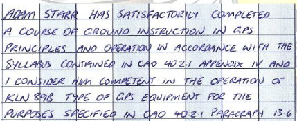
That was evidence I had completed the course and could use the GPS (it also happens to be evidence that I actually had a paperlogbook at some stage!). It also mentions the type of GPS and enforced further learning when you moved on to another type.
Now that we are in the times of the Part61 licence things have changed subtly. If you start your training now to become a pilot,you will automatically be taught all you need to know about GNSS systems as well as how to use your particular little box. This is decreed in the MOS with the knowledge unit of PNVC and the practical units of RNE and NAV. These are at PPL level so every pilot should have that skill/knowledge set and the NAV unit is also prescribed for RPL nav endorsement so that skill/knowledge set should have been taught and examined there as well.
Pretty straight forward so far. Now for the grey area! What if you had a CAR5 licence (without the CAO signoff) and you transitioned to a Part61 licence? You can tell if this has happened -well you will know your own as you did it yourself by providing a few reams of paperwork to CASA. You can tell if it has happenedto someone else as back on page 17 of their licence it will have these telltale little marks:
This may mean that you have slipped through the cracks of the syllabus change. When someone presents to me for this update,I simply run a course to the current MOS standard and then provide certification. That means that person is now equivalent to both of the other examples –a CAR5 conversion with the CAO certification and a straight Part61/MOS licence-holder.
You also NEED to be competent on this by law. CASR 61.385 states that, in order to exercise the privileges of your licence in an aircraft you MUST be competent in “operating the aircraft’s navigation and operating systems” as well as many other items.
Now that we are certified, is our aircraft? Was the little PFM box installed to a particular TSO? Is it of an appropriate type? These can be hard questions to answer and will involve a bit of legwork on you part. It is too much for this article,but I will delve into it more in another article. You can get a fair idea of your aircraft and avionics capability by just looking at the Maintenance Release and seeing if it is certified for IFR. You can (and I suggest if you are going to use GNSS that you should) also go through CAO 20.91 and examine where your aircraft fits. Another handy little place to look is in AIP GEN 1.5 and see if you have the right equipment to satisfy your operationas well as CAO 20.18 Appendix IV.
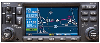
Let’s assume that you are now proven qualified to use themagic and the box/es in the aircraft are appropriately certified. Now can you use your GPS??
In most discussions,I have found the references revolve around what is in the AIP. To take it back a step further, I have even had discussions around the relevance of AIP. I was once told that the “I” in AIP stood for “Information” and, as such, was not binding and was for information only. I am always open for a good debate so let’s discuss this point before moving on. Firstly, if you have a look at some of the regulations (e.g. CAR 174D) they state that, with a regulatory basis, CASA may issue further instruction on how to navigate. I take that to mean AIP. Now I know that is an Airservices publication and not a CASA publication (as a debater once pointed out) so does not fit the letter of the law. But if we don’t take it to mean that then it must mean that AIP isjust for “Information” and can be ignored if we wish –including AIP GEN 1.5 that we discussed above so we don’t need TSO and can navigate on our iPads; we don’t need to obey the blue lines on the maps that are also considered part of AIP, in fact we don’t even need to use the standard phraseology or abide by any of the many requirements in ENR 1.1. I don’t subscribe to that theory (Isuggest you don’t either) and take AIP as a regulated direction from CASA.
Another point in some discussions revolves around phrases like “sole means” or “primary means”. These terms were around a while ago but seem to have faded a bit. Now it just seems that you need to be able to navigate by one of several methods.
AIP ENR 1.1 para 4.2 talks about navigating under the VFR and is oft quoted by people believing it states a VFR pilot must navigate by reference to ground or water. The other part of that same paragraph (AIP ENR 1.1 para 4.2.1(a)) follows on to say that you could also navigate by any of the methods inpara 4.1.1 except when operating at 2000’ or below (which is sensible). If you now go to para 4.1.1 that talks about IFR navigation. That means that a VFR pilot can navigate by visual reference to the ground or water OR by any IFR method –including GNSS which is an approved area navigation system.
The key here is that the GNSS, if used, must meet the performance criteria (i.e.TSO as discussed before)and you must be competent in its use which you would be under CARS 61.385 if you are flying that aircraft.
You can apply this to your own situation but lets just take a simple example. A VFR PPL holder goes and hires an IFR capable aircraft. This happens in a lot of places where the same aircraft is used for both IFR and VFR work. The PPL holder has been told that they can’t use the GPS and has therefore never been instructed in its use. The PPL holder then cannot hire the aircraft as they are not deemed competent under CASR 61.385. This means that the PPL holder needs to make sure they have the underlying knowledge by syllabus as described above (CAR5, Part61 or the grey area licence) and then be competent in the use of that unit. Once that has been achieved,they can quite happily and legally use that GPS to navigate.
So next time you go and fly, see if youhave a GPS, and satisfy the above requirements and, importantly, make sure the navigation database is up to dateon the unit. If all checks out,then go for your life.
Now, shouldI use my GPS?You still want to keep basic skills alive so practice them aswell. The two skills should go together–don’t rely on the GPS to the detriment of map-reading skills BUT also don’t rely on map-reading to the detriment of GPS skills!There are also a few caveats that are in AIP (as well as in any reasonable pilotsmind) about navigating above SCT cloud VFR. These warnings should be heeded and careful decision-makingprocesses and risk analysis performed before attempting this sort of flight. You can do it, but you had better make sure you can get back down! Position fixing is not an issue as it is not required under AIP (if using map/ground it needs to be every 30 mins, if by VOR 2 hours, but not needed for an area navigation system). It is prudent, however,to still put pinpoints on your map/EFB at regular intervals (by whatever means) and do your CLEAROF checks just in case something does happen.
Lastly, you also need to know what to put in your flight notifications which is in the AIP and for IFR pilots you need to be aware of quite a bit more of what you can do and what you need to notate. Both of these will be too long for here so will be the subject of separate articles.


There are many documents out there and various bits of legislation that are needed for a thorough understanding of this,but I will try to keep it simple and mainly refer to the AIP flight planning section –ENR 1.10.Appendix 1 to this section has copies of a flight notification form and a flight plan for reference. Immediately behind that is Appendix 2 where all the good bits hide!
Here we are just going to concentrate on Item 10 –Equipment and Capabilities. One of the more important things to note is at the beginning of this section. The letters you use are to indicate the “presence of serviceable equipment that the pilot is qualified touse” (and has approvals for where applicable). This can make a subtle difference where, for example, “S” is used “because its standard equipment” for everyone. “S” although “standard” includes VHF, VOR and ILS so may not be standard for VFR pilots nor mayit even be standard for IFR pilots who have chosen to not be certified or current with ILS.
The other thing we are just going to concentrate on is non-airline flying such as GA private, aerial work, instruction, charter etc. That means, for the scope of this article we can ignore things such as GBAS, LORAN, ACARS, CPDLC, MLS, SATVOICE, etc.
This is going to leave you with astring of possible letters that may be appropriate for you:
SDFGHLORVZ
These are the most common and pertinent to our sort of operation. Now let’sstart breaking that down a little further. Firstly,S is just a shortcut for V (VHF comms), O (VOR), and L (ILS) so it should be easy to figure out whether you may be an S or maybe a VO instead. A few of other easy ones are D (DME), H (HF coms) and F (ADF) which you either have and are certified to use or are not. So,if we take those letters out from the above,we are left with:
GRZ
Pretty simple huh!?!Well, this is where a lot of confusion starts.
A couple of other things to take note of are that “Z” is the same as in other places in aviation where it loosely means ‘look elsewhere’. If “Z” is used as an ATIS designator the tower is closed so you will need to look elsewhere for weather information and traffic. If “ZZZZ” is used in the flight notification as ADEP or ADES,then the system will look elsewhere for details of that little farm strip you are going to (i.e. DEST/2730S15327E). If we use it here,then the system is going to look elsewhere for some comment –in this case “NAV/……”.
A second note pertains to use of the letter “R”. Not only does it indicate you are PBN capable,but it directs the system to look for what that capability is under “PBN/….”. Like Z, R needs this other detail in the system so if it not provided then the system will error.
Finally, there is this note:

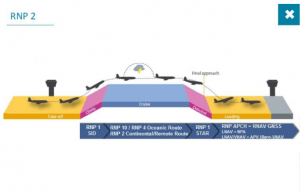
You should ignore the majority of this! Let’s put it into our context. The note itself is easy –if you have (for example) a TSO145/146 GPS and you plan to navigate by it then G and R should be in your flight notification. From the table,we won’t be doing Oceanic flying nor will we be doing GLS approaches so that only leaves three sections.Of these there is some debate around Terminal operations (i.e. PBN/O1 or O2) as the aircraft and pilot needs to be qualified for RNP SIDs and STARs which are RNP1 procedures and yet to make a big impact in Australia so for the majority of GA flight it is not appropriate. That only leaves us with Continental and Approach. Continental can be used for VFR or IFR operations (as discussed in a separate article “Can I Use My GPS”) but Approaches are IFR procedures.
CASA Aviationworx
When it talks about “Item 10” or “Item 18” these are simply the little areas where the data is stored. You willsee these little section numbers on the flight notification form example in Appendix 1 or you can just remember that “Item 10” is your nav/com equipment codes and “Item 18” is where all the other junk and notes go like NAV/, PBN/, RMK/. REG/, DLE/ etc. Toput it together into some jargon, if you note R in Item 10 then the system will automatically look for PBN/ in Item 18.
Now that we have some definitions, lets look at building up some letters.
Use S if it is suitable for you or you could just as easily use VO instead or even just V.
If you are using a properly installed and TSO’d GPS then you can use G and R but now we know R triggers the system to look for our PBN specification in Item 18. So what PBN are we? With those GPS receivers you will most likely be RNP2 (but you need to confirm that with yourparticular aircraft). But there is no code for that I hear you cry! AIP cries the same thing….
![]()
You can use the old RNAV5 specification of B2 from the table in AIP and then clarify this a little further with a NAV/RNP2 comment if you wish. In theory the system should be happy with just GRZ with NAV/RNP2 but, as you have noted R, the system may look for a PBN/ so using the old specification of RNAV5 (PBN/B2) will keep it happy.

That’s about all you need as a VFR pilot using GPS to navigate –VGRZ with PBN/B2 and NAV/RNP2.
As a pilot with an IR (Instrument Rating) you could ramp that up to SGRZ with PBN/B2 and NAV/RNP2. If you were able to do RNP2D approaches then you could add S1 to your PBN/ as well.

As a pilot with a PIR (Private Instrument Rating) you now need to make a few more notations to clarify what you can and can’t do so a controller doesn’t expect you to do something you can’t. For example, as a PIR pilot you can use “O” (VOR) in Item10 but only be able to track using the VOR, not do VOR approaches. As far as a controller can see you are an IFR flight that has nominated O so are capable of VOR approaches so we need to clarify this for them. To do that we just stick a few general remarks in Item 18 for them to read by simply using the RMK/. Examples are given in the table but are quite individual so you will need to make up your own combination depending on the FPAs you have.

So,there you have it. Its just a slightly different language but once you learn how to read it you can get quite creative and informative. That is all it is in the end –an abbreviated and standardised way of sending a note to the controllers so they can see what you want,and what you are capable of doing, in orderto help you out as much as they can.

Each of the following sections corresponds to a section in the POH. Any questions pertaining to the Flight Operations Manual will state (FOM)after the question.
Unless otherwise noted, all questions apply to the model of aircraft that you will be flying. If a question only applies to a certain model, it will be noted with:
 Download File